Log in
All resources
Create a design
11,660 Free Images of Old Map
bibliothèque nationale de france
maps by willem and johannes blaeu
baroque
atlas novus (blaeu)
details of old maps
maps of paris by braun & hogenberg
maps from the mechanical curator collection
maps from gallica
gemeente atlas van nederland - south holland
1860s maps of south holland
old maps of virginia in the american civil war
1863 maps of west virginia
maps made in the 17th century
old maps of lindau (bodensee)
maps by christian sgrothen
old maps of zeeland
maps from the earth and its inhabitants, vol. x
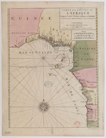
19th-century maps of africa
old maps of north holland
abraham deur
palatinatus rheni (merian)
baroque
maps from valentine's manual
george hayward
untrodden peaks and unfrequented valleys (1873)
old maps of the alps
palatinatus rheni (merian)
baroque
media from regionaal archief alkmaar
old maps of schagen
maps of paris by braun & hogenberg
maps of paris from paris musées
guide joanne espagne et portugal-1915
1915 maps
1780s maps of south america
maps in the british museum
maps from university of amsterdam special collections
atlas der neederlanden
17th-century maps of the malay archipelago
archipelagus orientalis
old maps of emden
baroque
jan karel donatus van beecq
hernán cortés
18th-century maps of azerbaijan
maps by isaak tirion
turgot map of paris, kyoto university library – derivative files
foire saint-germain on old maps
maps of valenciennes city walls
old maps of valenciennes
old maps of verona
adriano cristofali
st. helena - a physical, historical, and topographical description of the island (1875) by melliss
maps from the mechanical curator collection
maps from the earth and its inhabitants, vol. xi
africa in the 1890s
1866 in the netherlands
maps of almelo
elbe in brunsbüttel
brunsbüttel
german renaissance,humanism
old maps of cairo
eran laor cartographic collection
maps by tomas lopez
john rocque's 1746 map of london
northumberland house
old maps of north brabant
coats of arms on maps
landais & oberthur
maps from gallica
gemeente atlas van nederland - south holland
old maps of gouda
maps from university of amsterdam special collections
atlas der neederlanden
collections of the kriminalmuseum rothenburg ob der tauber
old maps of rothenburg ob der tauber
old maps of fictional countries
bernard sleigh
maps of paris from bibliothèque nationale de france
maps of paris by braun & hogenberg
joseon dynasty
heo mok
guide joanne espagne et portugal-1915
1915 maps
map of paris by braun & hogenberg - derivative files
porte papale
maps by willem and johannes blaeu
siege of groenlo 1627
charles eugène perron
old maps of trabzon
maps of paris from bibliothèque nationale de france
johannes de ram
gemeente atlas van nederland - south holland
old maps of gouda
tresor des cartes geographiques (1659)
old maps of the benelux
internet archive document dayswaysinoldbos00ross 0
days and ways in old boston (1915)
old maps of delft
atlas van loon
details of old maps of düsseldorf
pharus-plan
old maps of the bering sea
old maps of kamchatka
17th-century maps of lorraine
old maps of pays messin
africa and its inhabitants, vol. ii
charles eugène perron
nicolas desmarest
ambroise tardieu
gemeente atlas van nederland - south holland
old maps of leiden
old maps of the ionian islands
the odyssey (butler)
old maps of deventer
renaissance
old maps of narva
1700 maps
glaciers and glaciation (1910)
maps of inside passage
maps of the forest of fontainebleau
old maps of seine-et-marne
17th-century maps of africa
maps from gallica
old maps of the northern hemisphere
old maps of the arctic
den danske hærs historie til nutiden og den norske hærs historie indtil 1814
maps from the mechanical curator collection
maps of brest, france by antoine aveline
17th-century maps of brest
leipzig in the 17th century
baroque
1840s maps of palestine
old maps of israel
maps by william home lizars
old maps of sydney
maps from the mechanical curator collection available to georeference
maps from the mechanical curator collection
maps in the library of congress
1760s maps of china
old maps of duchy of troppau
maps of duchy of jagerndorf
old maps of san antonio, texas
maps by henry wellge
maps of mons city walls (hainaut)
old maps of mons (hainaut)
itinerario (jan huygen van linschoten)
16th-century maps of java
1895 maps of new york (state)
old maps of albany, new york
maps of paris from the david rumsey historical map collection
maps of paris by caspar merian
novus atlas sinensis
old maps of sichuan
maps by nicolaes visscher i
old maps of canaan
maps of barbary coast
old maps of tartary
maps in the library of congress
old maps of new hampshire
old maps of montana
julius bien
gemeente atlas van nederland - north holland
old maps of haarlem
17th-century maps of the black sea
maps by willem and johannes blaeu
plan routier de la ville et faubourg de paris by jean lattré
maps of paris from bibliothèque nationale de france
demographic maps of algeria
cartes de franz schrader
old maps of deventer
schipbrug deventer
old maps of khartoum
history of omdurman
maps by willem and johannes blaeu
old maps of brandenburg
city
town
camps topographiques de la campagne de mdcclvii, en westphalie
bornum (hannover)
1640s maps of lower saxony
atlas novus (blaeu)
hendrik van langren map of south asia
1590s maps of iran
old maps of the strait of gibraltar
1762 maps of spain
details of old maps, defaced
old maps of samsun
the turkish empire in europe, asia and africa (1752)
old maps of baghdad
maps in the library of congress
1889 maps of michigan
old maps of algiers
maps from gallica
maps of paris by braun & hogenberg
frans hogenberg
old maps of north rhine-westphalia
maps of balve
old maps of ostend
siege of ostend
old maps of manhattan, new york city
1851 maps
maps by pieter schenk (i)
maps by gerard valck
cartes de franz schrader
old maps of the alps
old maps of delhi
catalan atlas
oulu in the 1820s
classicism
7701 - 7800 of 11,660
Next page
/ 117


![Treasure of geographical maps of the main states of the universe [...], 1659](https://cdn.creazilla.com/illustrations/10000541161/treasure-of-geographical-maps-of-the-main-states-of-the-universe-1659-md.jpg)